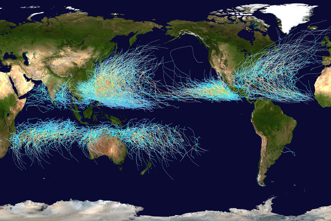
Cyclone Paths on Planet Earth


Where on Earth do cyclones go? Known as hurricanes when in the Atlantic Ocean and typhoons when in the Pacific, the featured map shows the path of all major storms from 1985 through 2005. The map shows graphically that cyclones usually occur over water, which makes sense since evaporating warm water gives them energy. The map also shows that cyclones never cross -- and rarely approach -- the Earth's equator, since the Coriolis effect goes to zero there, and cyclones need the Coriolis force to circulate. The Coriolis force also causes cyclone paths to arc away from the equator. Although long-term trends remain a topic of research, evidence indicates that hurricanes have become, on the average, more powerful in the North Atlantic over the past 30 years, and their power is projected to keep increasing.


from NASA https://ift.tt/3AeJYYT

Comments

Popular posts from this blog

A Spiral Aurora over Iceland

What's happened to the sky? Aurora ! Captured in 2015, this aurora was noted by Iceland ers for its great brightness and quick development. The aurora resulted from a solar storm, with high energy particles bursting out from the Sun and through a crack in Earth's protective magnetosphere a few days later. Although a spiral pattern can be discerned, creative human s might imagine the complex glow as an atmospheric apparition of any number of common icons . In the foreground of the featured image is the Ölfusá River while the lights illuminate a bridge in Selfoss City . Just beyond the low clouds is a nearly full Moon. The liveliness of the Sun -- and likely the resulting auroras on Earth -- is slowly increasing as the Sun emerges from a Solar minimum , a historically quiet period in its 11-year cycle. from NASA https://ift.tt/2XgnyIE

SuperCam Target on Maaz

What's the sound of one laser zapping? There's no need to consult a Zen master to find out, just listen to the first acoustic recording of laser shots on Mars . On Mars Rover Perseverance mission sol 12 (March 2, 2021) the SuperCam instrument atop the rover's mast zapped a rock dubbed Ma'az 30 times from a range of about 3.1 meters. Its microphone recorded the soft staccato popping sounds of the rapid series of SuperCam laser zaps. Shockwaves created in the thin Martian atmosphere as bits of rock are vaporized by the laser shots make the popping sounds, sounds that offer clues to the physical structure of the target. This SuperCam close-up of the Ma'az target region is 6 centimeters (2.3 inches) across. Ma'az means Mars in the Navajo language . from NASA https://ift.tt/qUSdeZl

The Gator Back Rocks of Mars

Wind-sharpened rocks known as ventifacts, cover this broad sloping plain in the foot hills of Mount Sharp, Gale crater, Mars. Dubbed gator-back rocks their rugged, scaly appearance is captured in these digitally stitched Mastcam frames from the Curiosity rover on mission sol 3,415 (March 15, 2022). Driving over gator-back rocks before has resulted in damage to the rover's wheels, so Curiosity team members decided to turn around and take another path to continue the rover's climb. Curiosity has been on an ascent of Gale crater's central 5.5 kilometer high mountain since 2014. As it climbs, it's been able to study layers shaped by water on Mars billions of years ago . from NASA https://ift.tt/IGon5ra